


Voting District 0004, Dallam County, Texas
About
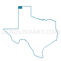
Outline

Summary
| Unique Area Identifier | 671823 |
| Name | Voting District 0004 |
| County | Dallam County |
| State | Texas |
| Area (square miles) | 261.13 |
| Land Area (square miles) | 260.58 |
| Water Area (square miles) | 0.54 |
| % of Land Area | 99.79 |
| % of Water Area | 0.21 |
| Latitude of the Internal Point | 36.37931770 |
| Longtitude of the Internal Point | -102.72865490 |
Maps


Graphs
Select a template below for downloading or customizing gragh for Voting District 0004, Dallam County, Texas


Neighbors
Neighoring Voting District (by Name) Neighboring Voting District on the Map
- Voting District 0001, Dallam County, TX
- Voting District 0003, Dallam County, TX
- Voting District 0006, Dallam County, TX
- Voting District 0007, Dallam County, TX
- Voting District 2, Cimarron County, OK
- Voting District 5, Cimarron County, OK
Top 10 Neighboring County Subdivision (by Population) Neighboring County Subdivision on the Map
- Dalhart CCD, Dallam County, TX (5,936)
- Boise City CCD, Cimarron County, OK (1,882)
- Texline CCD, Dallam County, TX (767)
Top 10 Neighboring Unified School District (by Population) Neighboring Unified School District on the Map
- Dalhart Independent School District, TX (10,235)
- Texline Independent School District, TX (961)
- Felt Public Schools, OK (303)